
Web Soil Survey
Material type: TextPublisher: Natural Resource Conservation Service Content type:
 - text
- unmediated
- volume
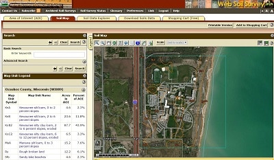
Produced by the Natural Resource Conservation Service (NRCS), the Web Soil Survey is a web based mapping tool which allows users to identify an area of interest by address or county and then analyze the underlying soil type. Identified areas can also be analyzed on a range of criteria including but not limited to: soil properties and qualities, suitability and limitations for use, and ecological functionality. NRCS has soil maps and data available online for more than 95 percent of the nation’s counties and anticipates having 100 percent in the near future.
Staff. Public.
Protected by copyright law.
There are no comments on this title.