
NOAA Great Lakes Environmental Research Laboratory ( GLERL)
Material type: TextPublisher: National Oceanic and Atmospheric Administration Content type:
 - text
- unmediated
- volume
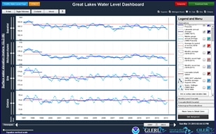
The Great Lakes Water Level dashboard was designed to help users view, understand, and compare Great Lakes surface water elevation data and forecasts from a variety of different sources, and across a variety of time scales ranging from monthly average values, to annual and multi-decadal values. For Great Lakes water level data and forecasts at a higher temporal resolution, we direct users to the NOAA National Ocean Service (NOAA-NOS) Great Lakes water level gauging station site, the Canadian Hydrographic Service site, and the NOAA-NOS Great Lakes Operational Forecasting System site.
Staff. Public.
Protected by copyright law.
There are no comments on this title.